Mapvwra用簡易地図/Rough Maps for Mapvwra
2017/06/20設置,2017/09/25更新
Samples of CSV format for Mapvwra
Easy format CSV for some New Zealand topographic maps
You can obtain images of New Zealand topographic maps from http://www.linz.govt.nz/land/maps/topographic-maps in LINZ website.
Remark: Old topographic maps of New Zealand are not drawn by a transverse Mercator projection, but by a very unique projection, New Zealand Map Grid Projection.
Therefore Mapvwra has slight errors, especially in small scale maps, like as below.
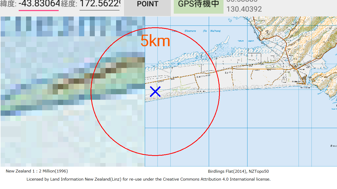
This image is drawn by the above CSV, fastening four corners of 1 : 2 million to the same places on New Zealand Transverse Mercator 2000.
Rough Maps
数値地図200000用KANRI2K.CSVのカラムに合わせた下記21図の四隅データ/Japan GSI format CSV for the below 21 maps
Easy format CSV for the below 21 maps
横メルカトル図法(二重投影)の地図/Transverse Mercator maps with double projection from GRS80
東経150度/East latitude 150 degree (png,1024px×2040px,39kB)
東経120度/East latitude 120 degree (png,1024px×2040px,51kB)
東経90度/East latitude 90 degree (png,1024px×2040px,48kB)
東経60度/East latitude 60 degree (png,1024px×2040px,52kB)
東経30度/East latitude 30 degree (png,1024px×2040px,58kB)
経度0度/Llatitude 0 degree (png,1024px×2040px,50kB)
西経30度/West latitude 30 degree (png,1024px×2040px,47kB)
西経60度/West latitude 60 degree (png,1024px×2040px,48kB)
西経90度/West latitude 90 degree (png,1024px×2040px,49kB)
西経120度/West latitude 120 degree (png,1024px×2040px,36kB)
西経150度/West latitude 150 degree (png,1024px×2040px,32kB)
経度180度/Latitude 180 degree (png,1024px×2040px,31kB)
メルカトル図法(楕円体補正)の地図/Mercator maps with double projection from GRS80
経度0度側半球/The Hemisphere centering long. 0 degree (png,2048px×2040px,153kB)
経度180度側半球/The Hemisphere centering long. 180 degree (png,2048px×2040px.106kB)
東半球/The East Hemisphere (png,2048px×2040px,145kB)
西半球/The West Hemisphere (png,2048px×2040px.114kB)
正距円筒図法の半球図/Equirectangular maps
正距円筒図法(標準緯度35°)による日本周辺/Around Japan by Equirectangular projection (png,1792px×1920px,169kB)
正距円筒図法(標準緯度0度)による東半球/The East Hemisphere by Equirectangular projection (png,2048px×2048px,120kB)
正距円筒図法(標準緯度0度)による西半球/The West Hemisphere by Equirectangular projection (png,2048px×2048px.119kB)
平射図法の地図/Polar-Stereographic maps
心射図法(楕円体補正)による北極周辺/The arctic by stereographic projection with adjustment on GRS80 (png,2048px×2040px,199kB)
心射図法(楕円体補正)による南極周辺/The Antarctic by stereographic projection with adjustment on GRS80 (png,2048px×2040px.102kB)
◎国土地理院の数値地図(200000地図画像)付属のKANRI2K.CSVであれば、テキストエディタなどで後ろに追加して、画像と同じディレクトリに入れれば使えます。
◎他の縮尺のKANRI2K.CSV、 あるいは200000地図画像用であってもKANRI.CSV、KANRI2KZ.CSV などは仕様がかなり異なるので、
第一行目の項目名を見ながら、位置が合うように挿入してください。
◎表計算ソフトで編集した方が簡単で間違いにくくなりますが、必ず「カンマ切り」で保存してください。閉じる際にリッチ形式で保存するよう警告を出すソフトもありますが、
それは無視してください。不安だったらテキストエディタで保存内容を確認してください。
◎1行目を見るといろんな項目名がありますが、直接計算に使うのは「図郭四隅緯経度」(度分秒単位)と「図郭四隅ファイル座標」(ピクセル単位)、自前で設定した場合の「中央子午線」だけです。
「図郭四隅UTM」は、対角線の長さが1以上ならUTM、そうでなければ正距円筒図法とみなします。内部計算で使う四隅のUTM座標は経緯度から自前で計算してるので、
csvファイルに書き込むのはいい加減な数字でもOKです。他に使っているのはファイル名(メッシュコード)と図名だけで、それ以外は全然使ってません。
◎指定した経緯度がどの地図画像に含まれるかは、上から順番に検索します。大縮尺を先に、小縮尺を後にしましょう。